After Mt Robson, we drove Wells Gray, hoping to get a campsite at Clearwater Lake. But we were too late, we camped at the Pyramid Campsite.
Water was clean, campsite was nice and close to trails. But ... lots of mosquitoes.
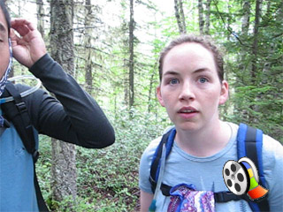
The next day, after we strolled around the Dawson Falls located the just out of camp. We decided to go for the South Rim Trail to see the Helmcken
Falls, the most famous waterfall in Wells Gray. Mid-way to the South Rim Trail, we learned that Clearwater Lake Campsite wasn't full, we decided
to turn back, double-time, back the campsite. While Christine was leading the doubletime, a family of black bears popped out from the woods. It scared
everyone of us, as it was a very close encounter ... and with 2 small cubs, the mother could be harmful to us. Make sure you checked the video below.
We moved camp to Clearwater Lake, where we spent a nice afternoon walking the Lakeshore Trail. Lots of cedar along the trail, we rested at the boat launch, about
2.5km off campsite. We bumped a few german tourists, and we offered help to haul their canoes up the shore. Meanwhile, rain started pouring on us. With some
hesitation, we decided to wait out the rain before getting back onto the muddy trail. Luckily, the germans who we helped earlier gave us a ride back to camp.
Everything started off at the visitor centre.
Camped at Pyramid campsite.
Mosquitoes, tell your bros, "Dont mess with us!"
Protection is the keyword here ... my friend!
Dawson Falls
We just came out from the Trail, ...
Insects here are BIG !.
Doubletime !
Not so fast, .... Christine practically ran into the bear mother from the woods.
Here is the 700 pound of meat ....
Watch this video clip. First close-up Bear Encounter(6.1 MB file).
More closeup pictures ...
We were in the car driving out already when we were taking these last 2 pictures.
2 cubs on the ground.
2 cubs on the trees ... cute teddy bears...
Clearwater Lake campsite.
Christine, you forgot to keep Carleton on leash.
Relfections off Clearwater Lake
This devil's club leaf was about the size of my head.
Lakeshore Trail
Clearwater Lake, ... it's really clear.
Start of our 17km loop hike ....
On the 2nd day, our goal was to hike the 17km loop up the Osprey Viewpoint, Meadows then joined the Lakeshore trail back to camp. Thirty minutes into the trail,
we ran into our second encounter into the black bears, also with cubs. This time, the elements had changed, we surprised the bears, and both cubs and the bear mother
climbed up the tree. We backed up about 100 feet, and tried to wait it out. On our second attempt to cross, the bear mom started huffing and scratching trees. She meaned
"business". We turned back to camp with no choice.
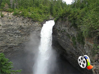
What should we do now ? We decide to do the South Rim Trail to see Helmcken Falls. It was a very nice afternoon. Arriving the viewpoint, we noticed that it was actually
quite dangerous place to be. (See the picture below). We had our lunch there to enjoy the famous Helmcken Falls, 70 metres plunge straight down. After that, we drove out of the
park and had our wonderfull ice-cream, filled up gas, and went back into the park. This time, we visited the Spahat Falls, and the Helmcken from the north side.
The morning before we left Wells Gray, we visited Ray Farm, Alice Lake and Mineral Spring. It was quite a tale to learn the Ray family farmed here in the 1930s. On the way back to Vancouver
we decided to detour and go through the 100-mile house, Lilloet, Pemberton, Whistler and back to Vancouver. We discovered a lot of good viewpoints where Fraser river travelled along the
canyons. At last, we were amazed that we successfully passed the "obstacle course" test driving from from Whistler to Vancouver at mid-night.
Ops ..... Second Bear Encounter on the trail. (8.1 MB file).
This is where we camped.
Notice any difference, ... we moved our tarp to cover more of our table.
Bailey's Chute.
Whirlpool at the bottom of Helmcken Fall.
Helmcken Fall.
Helmcken Falls (South Rim Trail View) (6.3 MB file).
Bravehearted Carleton was risking his life .... to take a shot.
Waaaaaaaaaaaa !
Notice the viewing platform on the north side !
Spahats Falls, ..why can't list the distince instead of time? 5 minutes mean what ?
me @ Spahats Fall
Like a miniature of Helmcken Fall
The offical entrance of Wells Gray Park.
Helmcken Fall (From North Side)
Tourists enjoyed taking pictures at the falls, they also enjoyed reading.
Can you figure out where we were before on the South Rim ? over there ....
Dinner time, mac & cheese with turkey sausage
... and green salad ...
Waaaaacha!
Ooooooosh !.
Last day, transformation process began.
Transformation completed.
Osprey Fall
Ray Farm
Mineral Spring
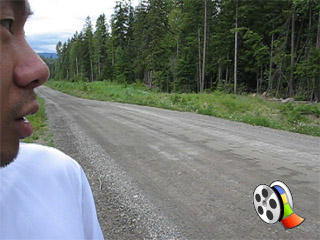
Road trip ...., our fearless documentary journalist in action again.
;)
;)
;)
;)
;)
;)
;)
;)
;)
;)
;)
;)
;)
;)
;)
;)
;)
;)
;)
;)
;)
;)
;)
;)
;)
;)
;)
;)
;)
;)
;)
;)
;)
;)
;)
;)
;)
;)
;)
;)
;)
;)
;)
;)
;)
;)
;)
;)
;)
;)