Finally Spring 2006 is here. Spring is the best time to visit Death Valley National Park. I drove from Las
Vegas for 2 hours and entered Death Valley National Park via Death Valley Junction.
The first site I visited was the Dantes View. It is 5475 ft above sea level. It allows visitors to see the
entire salt flats and valley from above. The 11-mile long road is very windy, and the last mile is very steep.
I then drove back down to visit Badwater Salt Flat. Directly below Dantes View, it is actually 282 feet below
sea level, one of the lowest point in the world.
Entering California State to Death Valley Junction
Don't make the wrong turn, or you'll end in Death Valley!
I did end up at Death Valley National Park.
Steep switchbacks upto Dantes View
Badwater Salt Flats from Dantes View.
I was very excited to be there to have this awesome view.
Entering 20-Mule Canyon Trail..
Still on 20-mule Canyon Trail.
Zabriskie Point.
View from Zabriskie Point.
They used to haul Broax (White Gold) out of these canyons.
Golden Canyon. I didn't have enough to hike in.
You're actually driving below sea level.
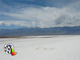
This is what I am coming to see. Badwater Basin.
The Salt Flat is really something to see. Firstly, it is so wide and flat that one seems fo small in this great plain
field. Secondly, it is surrounded by 5000 feet tall rock formation, and it makes you think it is the hidden treasure.
Telescope Peak and Badwater Salt Flats
Salt flat formation.
Me on the Badwater Basin.
Badwater Basin Click to play video.
Wow.....
What are you doing here ?
Man, there is a lot of salt here.
It is salty indeed.
I just can't have enough of these shots.
Is there someone cooking behind these mountains.
Salt Flat formation.
Salt Block is actually still wet.
Badwater Basin viewpoint.
Yes, it's below sea level.
I promised this is the last one.
Other below sea level locations.
I drove almost 2.5 hours to see these Joshua trees
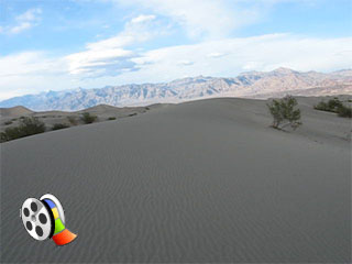
Sand Dunes time.
What a big change of scenery !
Plants still live here.
The sand ripples calm you down, doesn't it ?
I visited the Sand Dunes as my last stop before I headed back to Las Vegas. If I had enough time, I would have
spent more time at the Sand Dunes, and hiked out to the big one. It will take at least 1 hour to navigate through
these dunes.
It is one of the perfect time to view sand dunes.
Between 4:30pm to 5:30pm.
Can't stop taking these blue sky sand dunes wallpaper pictures.
Another one !.
The main Sand Dunes. I will hike in earlier in my next visit.
I hiked in about 30 mins to see this.
Kinda tough to take picture by yourself on sand.
Looks like Sahara ?.
Not quite yet ..... Dried bottom of one of the sand dune valley.
Hmmmmm...
Who wants to slide down ?
Going back to Vegas via Beatty.
Blue sky and sand ....
OK, I am going home.
Ok, those sand dunes are not natural. I drove this bulldozer to form the dunes.
;)
;)
;)
;)
;)
;)
;)
;)
;)
;)
;)
;)
;)
;)
;)
;)
;)
;)
;)
;)
;)
;)
;)
;)
;)
;)
;)
;)
;)
;)
;)
;)
;)
;)
;)
;)
;)
;)
;)
;)
;)
;)
;)
;)
;)
;)
;)
;)
;)
;)