It was an exciting trip, at least for me, the first time to drive my 4Runner on bumpy forest service roads.
Carleton, Chrstine and I drove to Chilliwack, and continued on the Chipmunk Forest Service Road. The first half uphill section
was very easy to manage, and the second half was quite steep, and else a lot of pot holes. After 14 kms of switchback climbing,
we finally arrived at the parking lot (the end of the FS Road).
The only trail marker, pay attention please !
Steep climb on the FS Road
See those switchbacks, we drove up thru the road.
Try downloading this movie clip, it will show you how bumpy the road was. Sorry it's a bit too long to
download, it is a 42 MB file.
Bumpy Road Click to play video (42 MB file).
This is BEFORE .....
Can't believe it's still blooming.
Passing thru Spoon Lake
Steady climbing the trail ...
This hike was relative easy and flat as we drove up to almost 4800 feet to start off. A few turns led us to a meadow where Spoon Lake lied
in the middle of 2 mountains, Lady Peak and Mt. Cheam.
There were a lot of blueberries along the trail. They tasted so fresh and good. Winds picked up as we gained elevation, slowly we saw
ice and snow. We were above tree line.
Blueberries in Carleton's hand
A field full of blueberries
The deep clouds keep covering "Lady Peak"
See the entire Fraser Valley
That's right. It is snow.
Mt. Cheam
Still a few hundred feet vertical
Wahleach Lake
They're almost there ....
Other hikers summiting Mt. Cheam
Only 100 feet away
Trailhead up Quick, it's cold ...
Behind me is a 1000 feet dropoff, too cloudy here that you can't really see
Reached Mt. Cheam Summit, 6940 feet, at 1:16pm
It's actually snowing when we're at the summit
Ah .... life is like a box of chocolate...
There were a few groups of hikers at the peak when we tried to summit, so we decided to wait until they came down. We had our lunch at about 100 feet
below the peak. Damn ! It's a bad decision. It was so windy and cold ......
But hey, summiting this peak is quite fun, the wind and coldness made us feel liek achieving something ....
Snow was quite fresh and heavy up there.
Coming down the misty trail
This is AFTER ...
We hand-picked up a box of Alpine "Organic" Blueberries ..
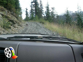
Driving down the FS Road ... Big pot holes Hold on ...
;)
;)
;)
;)
;)
;)
;)
;)
;)
;)
;)
;)
;)
;)
;)
;)
;)
;)
;)
;)
;)
;)
;)
;)
;)
;)
;)
;)
;)