It was a sunny day to start our drive to Golden, but unfortunately we bumped into "Rain" a few times on the road. But the rewards
were the nice rainbows that we saw.
The yellow school bus hauled our group (the first group) into Lake O'Hara. It wasn't a scenic
ride, rather it brought me the feeling of going on a high school field trip.
Well, we arrived and enjoyed the first glimpse of Lake O'Hara. Weather wasn't so great. It was cloudy.
Rainbow ...
Another Rainbow
What the !@#X? No bus service today ?
This yellow bus brought us into Lake O'Hara
Terry brought this classic canvas backpack
Don't run away from us...
Here you are !
Little blue flowers ....
This one is a "Single"ton
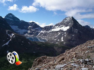
Odaray Glacier
Here we were at Lake McArthur
Lake McArthur is a biggest of all, see how tiny we are !
The first hike that I did was to Lake McArthur, the biggest within the Lake O'Hara area. We went from Elizabeth Parker Hut through
Lake Schaffer and arrived at McArthur. It was a "Wow.." feeling to see such a big glacier-fed lake. It has the soothing blue colour
that immediately calms you down.
We spotted some mountain goats on the west side of the Lake. We could barely notice their existence. See these pictures below.
Do you see anything in this picture?
Those little white dots (lower left)...
They are the mountain goats! Scrambling on the steep slope ...
What a lovely couple !
It's long road .....
Somebody call 911 ....
Linda Lake
Morning Glory Lakes
Fungus on the trail
Going somewhere, Len ?
Home sweet home, Elizabeth Parker Hut
On the way to Wiwaxy Pass ...
A few more hundred feet to go !
On top of Wiwaxy Pass
Lake O'Hara from Wiwaxy Pass
Going up Wiwaxy Pass was a long grinding trail, but the view was awesome. That hike was one of my favourites.
What goes up must come down ...
See anything ?
Mountain Goat on the ledge
Lake Victoria
Alpine Circut to Opabin Basin
What the !@#$% is that ?
First time I saw hiker with a retractable umbrella in a National Park. Len, you're the MAN.
Waterfall coming down through East Opabin Circut
How romantic was it ? Two men and an umbrealla !
Len, I thought you're the MAN, what happened here washing dishes ?
Summited on the Odaray Grandview
Sunday was the day to hike, beautiful blue sky with the sun up. Nada, Tony and I pounded up Odaray Grandview early morning to capture
the "Grandview" it offered. We could see most of the vicinity lakes from there, Lake McArthur, Lake O'Hara, Morning Glory Lakes, Linda Lake,
and Cathedral Lakes.
From the Odaray Grandview Click to play video (14MB file).
Lake McArthur from the Odaray Grandview Summit
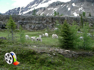
We went on to Lake McArthur afterwards. and enroute we walked into a herd of mountain goats feeding on the green. It was a very close
encounter with these sacred goats.
Mountain Goat (enroute to Lake McArthur)
Can't get another closer view than this !
Tony was still on the trail watching the goats
Action! Click to play video (14MB file).
It was my second time to Lake McArthur. And this time I saw a complete different lake. I went to the north side of the Lake, and
stood on the bluff. It was a very bright deep blue looking into the Lake, as if someone has just dyed the water to become
such beautiful blue.
We continued to summit our second mountain, Mt. Schaffer. We got as high as we can get to and had lunch up the ledges (can't really
get tothe peak). We saw the other group on the Grandview 2km straight line at the 8100 feet elevation.
Deep deep blue at Lake McArthur
Tony, Nada and I on Mount Schaffer See the old couple below us
Lake O'Hara from Mt. Schaffer
What is this sign? Alpine Route trail marker
Enroute to Opabin Lake
After Mt Schaffer, my mind was on hitting Yukness Pass, where Tony and Nada had already summited the day before. I need someone
else to summit with me. Fortunately I met 2 young men (Shawn from Toronto and Mike from Australia) on the way to Opabin Lake
and I convinced them to go up with me.
On top of Yukness Pass
Opabin Lake from Yukness South Peak
Lake Oesa from Yukness South Peak
It was my highlight of the day. It was a 1850 feet straight up with little sign of a trail. We just scrambled on loose and
sharp rocks and kept going up. I ran out of water half way up, without realizing there is a leak of my water bladder. I was
very thirsty and I am worried about "how can I get down?".
We summited both North and South Peak of Yukness. It was a refreshing moment standing on top of 9250 feet mountain. Looking
north, we saw Abbot Pass, where Abbot Hut was built. Looking west, we captured the view of the entire Lake O'Hara Valley and
as far as Cathedral Mountain.
For those who are interested in knowing about the Abbot Hut (Built in 1922), a National Historic Site, please click
here.
;)
;)
;)
;)
;)
;)
;)
;)
;)
;)
;)
;)
;)
;)
;)
;)
;)
;)
;)
;)
;)
;)
;)
;)
;)
;)
;)
;)
;)
;)
;)
;)
;)
;)
;)
;)
;)
;)
;)
;)
;)
;)
;)
;)
;)
;)
;)
;)
;)
;)
;)
;)
;)
;)
;)
;)
;)
;)
;)
;)
;)
;)
;)